and occasionally rides a bike.
A word of warning. The walk descriptions are not detailed enough to guide you - please take a map. The batteries never run out, and you always have a signal. Oh, And don't take left or right as gospel!

Thursday, March 24, 2016

Irthlingborough Lakes and meadows

10.15 on Thursday 24 March.  A walk of just over 7 miles with Maureen. An exploratory walk from the Irthlingborough end of Stanwick Lakes. Dry, still not warm, and some drizzle toward the end.

This was basically a walk following our noses and the maps on site, with the help of phone apps to orientate ourselves. We parked near the old football ground, along with several other cars.  Our walking route went more or less south west (turning right at the old railway track, away from Stanwick Lakes and towards  Northampton. Irthlingborough was on our right, Higham Ferrers on our left, across the A45.

 The Nene was looking grey and uninviting.
 This is a footbridge carrying the Nene Way over the river.  The noisy A45 is close by as well.
 A couple of examples of stone "wildlife".
 We had a break, balancing on a log, and then found a bench a hundred yards further on.
Irthlingborough with its distinctive church.

There were quite a few grebes, swans, coots being noisy, Canada geese and some little birds in the trees.

We decided to add a couple of miles on at the end and called at the Visitor Centre for coffee and teacakes.

It began to drizzle, but no serious rain, though I had to use the screen wipers as we drove home.

Now I just need to decide on a route for the Gretton group.

Map and details


Pitsford Water anti-clockwise

A gentle wander round the reservoir, with Marta, on a pleasant dry day. (March 22nd)

We were quite close to a great crested grebe, but with only the little camera I kept just missing  it.  Here are the results:
It was there, really


(I blame the tools! )

Tuesday, March 22, 2016

Stoke Albany, Ashley,Brampton Ash,Desborough

9.33 am, Monday 21 March 2016. Led by Tommy, with me, Maureen, Gordon, Marian, Chris, Terry. Dry, but not sunny. fields are drying out. 9.5 miles, and around 660 feet of climbing, though none of the hills were very long, and the views were good, in spite of some mist.

We parked at the village hall, near the church in Stoke Albany, and took the footpath heading north west by the church. it turns more or less north, past Lower Lodge farm, and under a row of pylons, joins a path from Wilbarston and heads north west again.  
A hardy band walks along the corridor in the fields
  On the outskirts of Ashley, we take a path east, cross a minor road and climb steadily up across field paths to the finger post where six paths join.
Six ways finger post to Stoke Albany (x2), Brampton Ash, Sutton Bassett, (hidden away at the back), Weston by Welland and Ashley
 We join the Midshires and Macmillan Way and follow the footpath towards Brampton Ash. We have a break - fairly high up, but sheltered between two rows of trees.
Renewed enthusiasm after a break - and we found a spot out of the wind.
 We cross the Harborough Road, and walk across a field near Brampton Ash church to reach Hermitage Road. A turn to the right and a short section on the road takes us to another footpath, on our left,leading to Red Hovel, and then alongside Brampton Wood. This is on our left.
Brampton Ash church, and lots of new lambs.

More new life
 Our route takes us through an industrial estate on the outskirts of Desborough, and along a public footpath over a locked gate, then across a field with a few horses, before following the other side of the wood - it is now on our left again as we walk north. We skirt Stoke Wood, and reach the minor road between Desborough and Stoke Albany. A mile or so and we arrive back at the church, and the cars. 
Back to Stoke Albany church
Map and details

Saturday, March 19, 2016

Fineshade Top Lodge

With Marta. No photos today, so this is just for the record - a six-mile walk around the still bleak woods - along paths where much tree-felling has taken place. We saw catkins and primroses, but the wind was still chill. A few kites and a couple of kestrels spotted, but this was very much a walk-for-walk's-sake, followed by a surprisingly decent lunch of beetroot and mint soup.

Thursday, March 17, 2016

Pitsford Water clockwise

With Gordon and Maureen. Fine, sunny, though not warm. The wind is still blowing chill. Just under seven miles.


Tuesday, March 15, 2016

Great Oakley, Little Oakley, Newton, Geddington and back

Led by Gordon, followed by me. 9 miles on a fine sunny morning, with a noticeable wind chill. Not as muddy underfoot as I expected, considering all the rain last week.
From Levin Road , at the mini roundabout we turned right to go past the cricket club, following the path, eventually going under the railway line and the new A43. That bit is not the most scenic, but most of the walk is good!
We walked behind Little Oakley Church, then over field paths towards Newton.

L
Little Oakley church - my little camera was set on 'silly effects'.
We called in at the Dovecote farm shop and Buttery for a coffee/tea and teacakes, then did a loop around to Grange Road, and the field behind Geddington, down to Mill Farm, past the old dovecot and the Newton church field centre, where lambs are now in evidence.
Newton church/field centre, and some outdoor lambs.

Reign of James I and VI . . .
We closed the loop by retracing a few hundred yards from the Buttery, whose car park had filled up rapidly for lunch. We walked along a track until we joined another footpath heading down over several fields towards the A 43 again. The footpath is now diverted and adds a good half mile on to the original walk, but sometimes this has to be done.  We enter the Great Oakley Estate and take a footpath to the left. There are concrete paving stones through the field, leading gently downhill into Great Oakley. 
Inside the park of Great Oakley estate.
Finally a pleasant stroll through the parkland, and along Church Drive, takes us to Brooke road. We turned right and walked through the old village and back to Levin Road.

A lovely walk on a fine day. Thank you, Gordon.


Monday, March 7, 2016

Islip, Denford, Woodford Mill, Ringstead

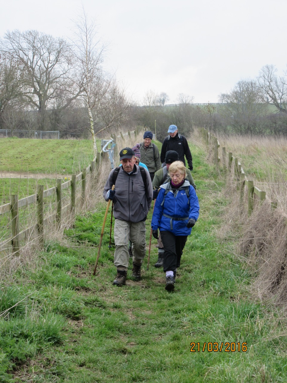
On a very fine, bright and frosty morning five of us set out on this gentle walk from near The Woolpack Inn in Islip, just before the bridge into Thrapston. The walk was extended for an extra mile or so from the original as the weather was good, and there were only five of us.

We followed the Nene Way over the field, across the disused railway and turning east alongside the A14. It goes under this noisy road and turns west, following the road for a short distance before turning on to the disused railway track path toward Stanwick Lakes.
Very soon the footpath which forms part of the Nene Way turns off to the left, just after a bridge. You keep close to the hedge, on your left. A footbridge takes us into the next field, and now we keep the hedge on our right until we reach a gap. We turn right across the field. On the OS map the track goes diagonally over this big field, but on the ground it's slightly different. We come to another bridge/stile and in the next field take a diagonal path for the bridge at Denford Lock. 
We cross the bridges towards the village.

We wander through the village of Denford and then back to the river.

A pleasant spot, but too early for a break!

Just after the third bridge we turn left along the footpath which follows the river as it curves round to Woodford Lock. This is very pleasant walking, and easy underfoot apart from the odd wet gateway. We turn left along the track towards Stanwick Lakes, crossing the viaduct, then going through the bridge carrying the Ham Lane track, and over another viaduct. In about a mile we reach the sign for the Woodford Mill tearoom, and head over there for coffees and teas.

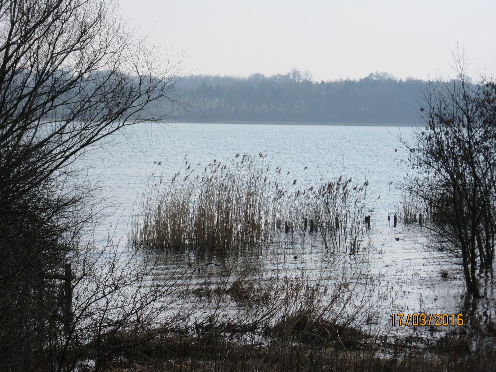
After a break we agree to extend the walk by a mile or so, and take the road toward Ringstead, but turn off to the left and follow a footpath alongside Kinewell Lake.


We pass the car park on our right, and soon afterwards walk through a kissing gate and along a fenced-in path which comes out near the Axe and Compass pub. We walk through the village, past the Post Office and shop, and up a short hill past a building site, to pick up the path leading to Denford. This follows a hedge to our left, some allotments on our right, and there is one sticky field to cross downhill, and back into Denford.

We pick up the route over the river (third crossing of the bridges today), and the Nene Way back to the railway track. We turn right this time and head under the A14 and directly back towards Islip.


Friday, March 4, 2016

Thrapston Denford Ringstead


Fri, 4 Mar 2016 9:51 GMT
With Marta. Cold day with wind, but warm sunshine too. Just under 7 and a half miles. Flat. Some mud.

From Thrapston, just by the Woolpack, along the Nene Way then into Denford. (A little wetter than yesterday.)Turn right through the village, and follow Ringstead Road until a footpath leaves where the road bends left.  Follow the clearly marked footpath as it climbs uphill across a muddy field, though this was firm today. 
The path then goes by the hedge over grass, and alongside some allotments before reaching Ringstead. We walked towards the church, and turned right along Church Street. We found a suitable place for a break at the Memorial Playground, with benches and tables. 
Then we continued along Station Road, and crossed over on to the track leading all the way to the disused railway track from Stanwick Lakes. We turned right and walked the three miles back to Thrapston along the track.


Thursday, March 3, 2016

Thrapston, Denford,Woodford Mill

Thu, 2016 Mar 3 9:57 AM GMT.
With Maureen. Break at Woodford Mill Tea shop. I reckon about 8 miles. Lovely weather.


A further recce to check distances and conditions! We followed the Nene Way, then diverted into Denford.

Sunlight on water lifted the spirits.
The Nene from the bridge near Denford
A springlike scene today.


Denford church has a beautiful position near the river
This swan rivals the model for the village sign.

We walked back to the Nene Way, then followed the footpath alongside the Nene until it met with the disused railway track which goes to Stanwick Lakes.
One of the places where the old railway crossed the river.

We left the railway track to visit Woodford Mill tearoom.
Behind the tearoom at Woodford Mill.

Finally we walked along the road, turned right into Station Road and rejoined the railway track. We followed this all the way back to Thrapston.